On June 7, 2024, a 55-foot power boat named Gemini eased into the limpid waters of Pelican Bay. Situated on the southeast side of Dauphin Island, where a narrow sandspit known as Pelican Island bends southeast like the spur on a rooster shank, this delightful little body of water offers a scenic and relaxed atmosphere for beachgoers and boaters. Pleased to have found such a haven, Gemini’s owner posted a review on waterway.com. “This is a great anchorage,” he enthused. “Well protected from the waves of the open Gulf with sandy beaches all around you… Anchored for two weeks, anchor held tight through multiple fast-moving storms. Beautiful sunsets.”
What Gemini’s owner may not have known is that Pelican Bay once served as a major roadstead and destination for the region’s earliest French settlers until a devastating storm blocked its deep-draft passage. Where sailboats and Stauter-Builts now peacefully bob, three-masted frigates and trim brigantines once rode at anchor, and where swim-suited tourists comb the beach and admire the view, diverse characters like Mobile’s founder Pierre Le Moyne Sieur d’Iberville, the Pélican Girls, white-coated French marines, cassocked Jesuit priests, plundering pirates, the extravagant Governor Antoine de la Moth Cadillac and enslaved Africans all formed their first impressions of colonial Louisiana.
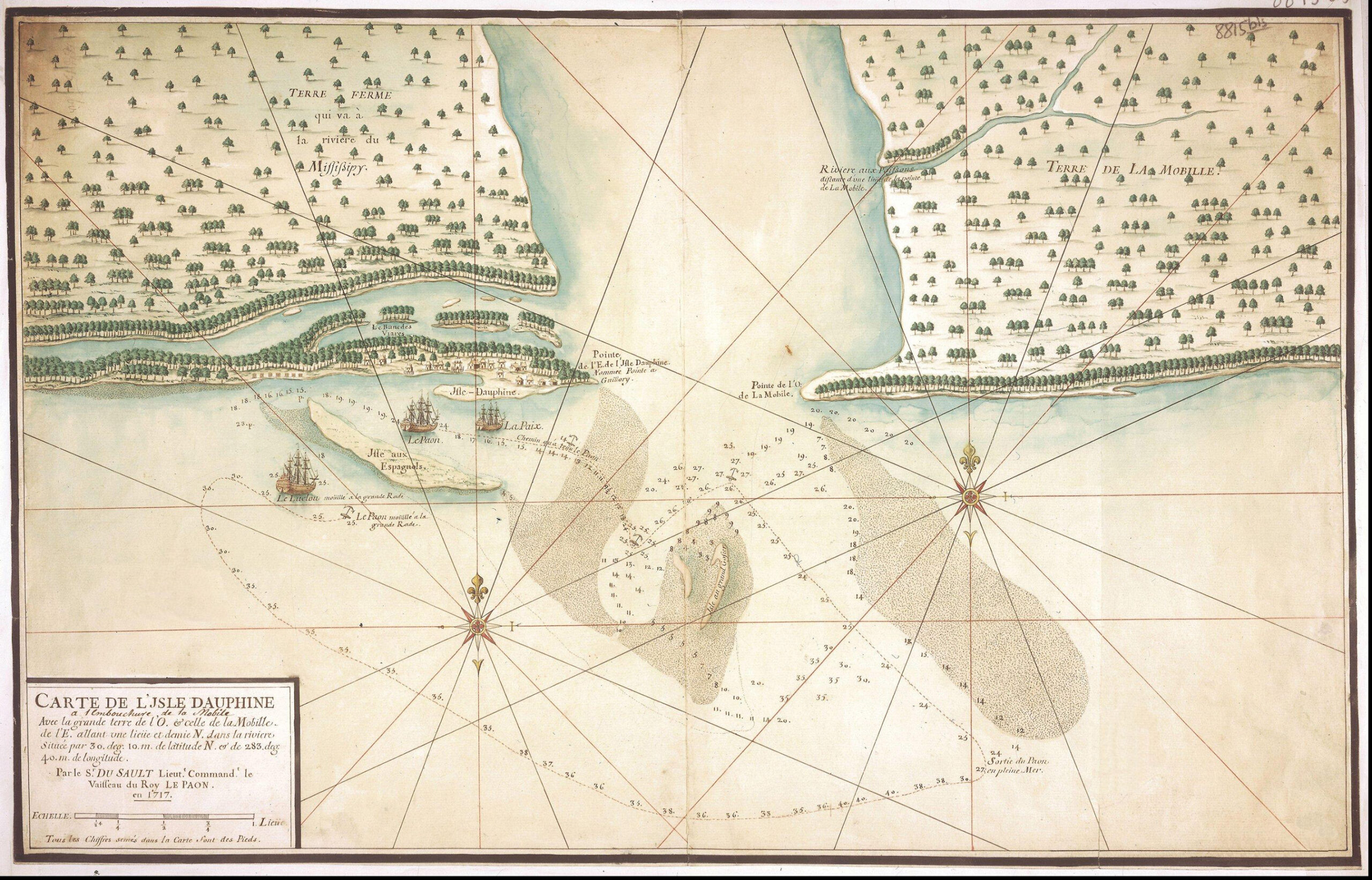
Scientists define Pelican Bay as an ebb-tide delta region since it lies where the heavily sedimented waters of Mobile Bay merge with the Gulf of Mexico, creating a plethora of continually shifting sandbars and shoals. During the late 1690s and early 1700s, the French explored the area during several voyages. At that time, Pelican Bay’s depth was more than 20 feet, and a navigable but narrow passage between Pelican Island and Dauphin Island linked it to the Gulf.
Iberville first entered the little cove through chilly mist and mizzle during the winter of 1701. As his longboat nosed onto the sand, he described fog so thick “we could not see our ships.” Among his followers was a young carpenter with a penchant for journaling named André Pénicaut, who described the Bay as “a crescent-shaped harbor” where “thirty ships could be sheltered. The channel to it and all adjacent waters were sounded and found to be good.” Equally impressed, Iberville’s brother Joseph Le Moyne de Sérigny wrote, “There is a good bottom at all parts of this roadstead; it is one of the best harbors on all this coast, and vessels of 40 and 50 guns would be completely safe here.”
As they trekked across the large barrier island that protected their little anchorage from howling north winds, the French discovered a mound of skeletons, and thus named it Massacre Island. They dubbed what is now Pelican Island the Isle aux Espagnols (Island of the Spaniards).
Given his druthers, Iberville would have preferred Pensacola Bay for his settlement since it was better protected, but the Spanish were already in possession there. In the meantime, he had established Fort Maurepas at Biloxi to guard the Mississippi River. But as he explored Mobile Bay, Iberville appreciated its advantages over Biloxi. It lay closer to important Indian allies, it had richer soil and its river system penetrated deep into the critical hinterland.
Once Iberville decided to establish the capital upstream at Mobile, Pelican Bay, then called the New Port, logically became the colony’s principal harbor. Its deep water, easily defended entrance and ready access to Mobile Bay and the delta made it King Louis XIV’s most strategic possession on the entire Gulf littoral. As the colony’s commissary Nicholas de la Salle optimistically reported to Minister of the Marine Paul Phélypeaux de Pontchartrain, “The harbor will serve as an entrepot for all the trade we shall do both on the great river Mississippi and on all the other neighboring streams.”
Throughout the winter of 1702, the cove bustled with activity as vessels large and small came and went between there and Biloxi, Havana, Veracruz and France, unloading settlers and supplies. Within a few years, Massacre Island, which the French soon renamed Isle Dauphine, had a vibrant little community near the anchorage. Port Dauphin, as the colonists called it, consisted of about two dozen people, cattle, chickens, pigs and some 25 houses, gardens, a church, wells, a modest fort and the commandant’s quarters.
On Feb. 18, 1702, Iberville visited the fledging colony on board his 48-gun flagship Renommée. The pilot skillfully guided the vessel into Pelican Bay and dropped anchor in 30 feet of water. “Here one is sheltered,” Iberville observed. “Ships moored in this harbor are secure from wind and sea.” But even as he got to work administering the colony, Mobile’s founder worried that a “stiff southerly gale” might shift the harbor’s surrounding sand bars, a fear hardly lessened after just such a wind tossed a bateaux onto the beach where sailors struggled for days to refloat it.
When Cadillac arrived as Louisiana’s new governor in 1713, he shared his own reservations about the anchorage to Pontchartrain. “Four vessels can lie at anchor in the port or harbor,” he wrote. “I should not like to swear that it will not some day be overwhelmed by some hurricane that might over-run the islet or the sandbanks that form it.”
Cadillac’s gloomy prediction materialized in late August 1717, when a hurricane struck the central Gulf coast. According to Pénicaut: “…the entrance to the Isle Dauphine harbor was blocked by a stupendous mass of sand, which a dreadful storm piled up there. This was the reason that no ship has ever since been able to get in. The waves from the sea drowned a great deal of livestock on Isle Dauphine.” The storm also trapped two light frigates inside the harbor, until they managed to carefully thread their way out through the treacherous shoals to the southeast. Unfortunately, the harbor’s closure diminished Mobile’s importance, and the French moved the capital to Biloxi in 1720 and then New Orleans in 1723.
Even though the storm ruined the harbor for ocean-going ships, lighter-draft vessels have used it ever since. During 1766, for example, the British naval surveyor George Gauld anchored his schooner there for several weeks while he worked the surrounding waters. His resulting chart was the first to use the names Pelican Bay and Pelican Island, likely inspired by an active rookery rather than as an homage to the Pélican Girls. No matter the name’s origin, Pelican Bay remains an inviting body of water and a fine place to contemplate our long and eventful history.
John S. Sledge is maritime historian-in-residence at the National Maritime Museum of the Gulf. His new book, “Mobile in the Heart,” is due this Christmas.